

In the next 30 to 50 years, rising sea levels caused by global warming will subsume low-lying islands in the Pacific Ocean. Inhabitants will have to relocate, but there are few choices. Among nations (with the exception of Fiji and New Zealand) there is little preparation for the inevitable migration of Pacific Islanders. Which nations should commit to the processes of equitable relocation?
The following article will address this question through historical context and colonial occupation; current legal debates surrounding climate change and maritime migration; and the potential rights of “deterritorialized” states, such as retention of exclusive economic zones. Historical context includes an examination of U.S. insular territories in the Pacific and the continued exercise of presidential authority over island possessions.
There are strong arguments to be made that the United States has ethical obligations to assist Pacific Islanders as sea levels continue to rise, with assistance taking many forms. The U.S. is obligated namely because it is the second largest emitter of greenhouse gases, and the largest carbon emitter historically; it has extensively tested atomic and hydrogen bombs and biochemical agents in the Pacific Ocean (Marshall Islands, Christmas Island, Johnston Atoll); has commercially profited from the Pacific ecosystem since the early days of whaling; and in addition to American Samoa, Guam, and the Commonwealth of the Northern Mariana Islands, possesses eight insular territories referred to as “United States Minor Outlying Islands.”1
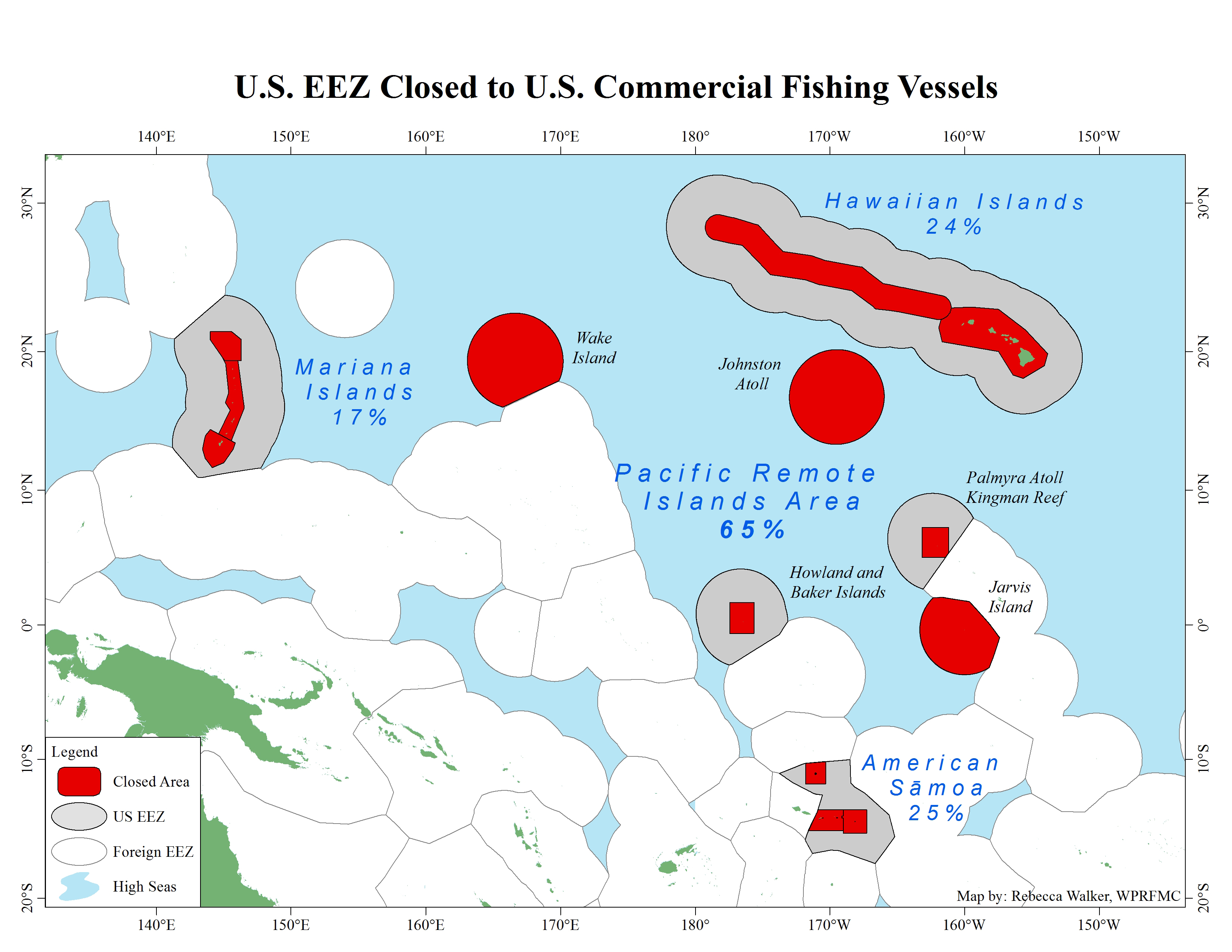
The U.S. Minor Outlying Islands are Baker Island, Howland Island, Jarvis Island, Johnston Atoll, Kingman Reef, Midway Islands, Palmyra Atoll, and Wake Island. (A ninth minor outlying island, Navassa Island, is located in the Caribbean Ocean, near Haiti.) Around these insular territories is an exclusive economic zone (EEZ) of 200 nautical miles. The National Oceanic and Atmospheric Administration defines the EEZ as “the zone where the U.S. and other coastal nations have jurisdiction over natural resources,” such as fisheries, energy, and other mineral resources.
When the zones of the eight minor outlying islands are combined with those of American Samoa, Guam, Hawaii and the Northern Mariana Islands, it forms a U.S. EEZ in the Pacific Ocean of 2.2 million square miles.2 The United States, seen in this light, is not a distant observer to the Pacific Islanders’ plight but an invested neighbor with shared history; a history defined in large part by commercial exploitation and continuing military entanglements.

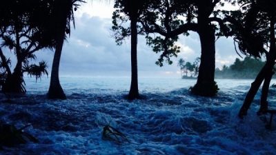
Over-wash event, Ejit Island, Marshall Islands. (Photo courtesy of Alson Kelen)
American Polynesia
The U.S. Minor Outlying Islands in the Pacific are small, low-lying formations of more biological use to birds and sea turtles than humans, but they have considerable strategic value. The islands are often referred to militarily as “picket fence” outposts. Most have airstrips, three have seaports, and two have lagoons that can accommodate seaplanes.3 Seven of the eight territories, however, didn’t begin as military acquisitions; American citizens claimed them under the U.S. Guano Islands Act of 1856.4 In the beginning, what could be found on the surface of “guano islands” had economic value. In the 21st century, economic value is in the control of their territorial waters and exclusive economic zones.
The Guano Islands Act “legalized” the taking of islands by American merchants in search of seabird guano, a powerful fertilizer used to enrich depleted agricultural land in the United States.5 The best guano (huano) came from Peru’s Chincha Islands, but American entrepreneurs grew impatient with what they perceived as an unfair monopoly. The 1856 act supplied the means to bypass the Peruvian marketplace by allowing U.S. citizens, such as Alfred G. Benson and James W. Jennett, to create their own guano empires in the remote reaches of the Pacific Ocean and the Caribbean Sea. And it gave the U.S. President authority “to employ the land and naval forces of the United States to protect the rights of the discoverer or of his widow, heir, executor, administrator, or assigns.”
Sixty-four noncontiguous island territories in the Pacific were claimed under the act, which provided an opportunity to reinvent plantation culture abroad as disagreements over slavery were reaching a boiling point in the continental United States.6 Guano extraction on isolated islands was disproportionately performed by Pacific Islanders, and overseen by white supervisors. As Jimmy M. Skaggs writes in The Great Guano Rush, there was no 19th-century job “as difficult, dangerous, or demeaning as shoveling either feces or phosphates on guano islands.” Whether laborers were contracted, coerced or outright kidnapped, there was no means for escape once sequestered on remote islands. And while most “American guano mining operations were unquestionably more humane” than those on Peru’s Chinchas Islands, “none were pleasant.”7
Once divested of guano, some islands were planted with coconut palms for the production of copra, which went beyond the original intent of the act (i.e., allegedly to facilitate a supply of affordable guano for the benefit of American farmers). Over time these small insular possessions became stepping-stones for larger ambitions. According to Gregory T. Cushman in Guano and the Opening of the Pacific World,
“U.S. claims under the 1856 Guano Islands Act represent an important landmark not only in the history of U.S. imperialism but also for the place of remote islands in global geopolitical history… In later years, these islands took on new geopolitical importance as coaling stations, relay points for undersea telegraph cables, and eventually as air bases.”

The United States is an Ocean Nation. The U.S. EEZ [shown in dark blue] is the largest in the world, spanning over 13,000 miles of coastline and containing 3.4 million square nautical miles of ocean—larger than the combined land area of all fifty states. (Caption and map by NOAA)
“By the end of World War I,” writes Cushman, “nearly every insular territory in the Pacific Basin except on the southern rim was theoretically subject to some distant government.”8 The U.S. territorial realm, in this Pacific mosaic of foreign powers, is known as “American Polynesia.”9

In 1859, German geographer E. Behm named the U.S. territorial realm in the Pacific, “American Polynesia.” The term appeared in his article on guano island claims, published in Petermanns Mitteilungen.Two maps accompanying the article. The one above illustrates each foreign country’s possessions lassoed in a distinct color.(Permission to reprint courtesy Gotha Research Library of the University of Erfurt, SPA 4° 000100 005)

Detail of Behm’s map.
Guano to Nuclear Testing
The early annexation of guano islands by commercial interests explains why access to Christmas Island (Kiritimati) for testing nuclear weapons, first by the U.K., then the U.S., was easily facilitated. How economic rivalry in the 19th century turned to military alliance in the 20th century involves a more complex telling.
Americans and the British both mined islands claimed under the Guano Islands Act, though not simultaneously.10 If American interests didn’t continuously work or occupy islands they claimed title to, the British seized the territory for the Crown. American claimants would object, mainly from afar, while other objections were registered by a visit to the island from the U.S. Navy (none resulted in military confrontation of any real consequence).11 Ownership disputes over guano islands turned to partnership, however, in the late 1950s when the British government sought to conduct full-scale H-bomb tests in the Pacific Ocean.
In a post-Lucky Dragon world, there were few willing partners.12 Australia and New Zealand, both Commonwealth states, declined Britain’s request to use adjacent waters. Australia had a 50-kiloton limit on tests and an embargo on thermonuclear weapons. New Zealand rejected Britain’s use of the nearby Kermadec Islands because Prime Minister Sidney Holland feared it would be “a political H-bomb.”13
That left territories in the central Pacific: Christmas and Malden Islands. A.G. Benson’s U.S. Guano Company had claimed both islands in 1858. A few years later, the British took possession, leasing Christmas Island to Lever’s Pacific Plantations in 1902. Plantation workers, described by various sources as Tahitians (1937) and Gilbertese (1956), lived in two principal settlements on the island, named London and Paris, as well as “small camps scattered among the coconut groves.”14
On the basis of sovereignty disputes, the U.K. informed the United States in 1955 of its plans to use both islands to test megaton thermonuclear weapons, with Christmas Island serving as the main base. The U.S. had no objections. Likewise, the British wouldn’t object when the U.S. launched Operation Dominic in 1962, which included atmospheric testing at Christmas Island using U.K.-built infrastructure.15
Those not consulted were the Islanders themselves. During the British operation, codenamed Grapple, work in the coconut groves ceased and their labor subverted to jobs in support of military operations, in order “to allow more British military personnel to undertake tasks directly related to the nuclear weapons program.”16
Sovereignty disputes came to a partial resolution in 1979. That year, the Republic of Kiribati declared its independence from the U.K. and the U.S. signed the Treaty of Tarawa. The treaty relinquishes U.S. ownership of Christmas Island, now called Kiritimati, and 13 other islands claimed under the Guano Islands Act. While the treaty recognizes Kiribati’s territorial sovereignty of the islands, it comes with a caveat: “any military use by third parties of the islands…shall be subject to [U.S.] consultation.”
The treaty also leaves open the future construction of U.S. facilities on three of the surrendered islands: Canton, Enderbury, and Hull.17

Kiritimati Island (formerly Christmas Island) was discovered by Captain James Cook in 1777. The majority of the island’s inhabitants work on coconut plantations and in copra production. The island’s major airbase is on the northeast side of the island. Nuclear tests were conducted on Kiritimati Island by the British in 1957 and 1958 and by the United States in 1962. (Caption by CIA/Image by NASA)
Guano, Nuclear Testing, Chemical Weapons
Another guano claim converted for U.S. military use is Johnston Atoll (Kamala), located about 800 miles southwest of Honolulu. The atoll, claimed by the Pacific Guano Company in 1857, consists of four islands on a coral reef platform, all of which have been artificially expanded by blasting, dredging, and reconstruction programs. According to NOAA, the U.S. Navy began preparing the atoll for military operations in 1939 by enlarging the main island (also named Johnston). Construction lasted until 1942, followed by a second phase in 1963. That year, Johnston and Sand Islands were further enlarged and two artificial islands created, called Akau and Hikina. Johnston, by far the largest of the four, is 16 times its original size and resembles an aircraft carrier.18
One phase of expansion on Johnston Island involved construction of a launch pad for high-altitude missile tests for Operation Dominic in the 1960s. Two of the tests were aborted, with radioactive contamination falling on the runway. Forty years later, in 2002, the Air Force “finished burying thousands of cubic meters of plutonium-contaminated waste in a 25-acre landfill on the atoll.”19
Other uses of the atoll include open-air biochemical testing; chemical weapons storage; and destruction of nerve agents VX and Sarin, sulfur mustard gas, and Agent Orange. Stockpiles of chemical weaponry were transported from Okinawa, Germany, and the Solomon Islands and incinerated on site using the Johnston Atoll Chemical Agent Disposal System (JACADS).20
Military operations on Johnston Atoll officially ceased in 2005. The atoll is now a designated wildlife refuge and national monument, with jurisdiction split three ways. The emergent lands of the atoll—that is, the four visible islands—are still under the administrative authority of the Air Force, while waters from 0 to 12 nautical miles (nm) seaward are protected as units of the National Wildlife Refuge System administered by the U.S. Fish and Wildlife Service. From 12 nm to 200 nm seaward, NOAA manages fishery-related activities. At this writing, commercial fishing is not allowed.
The prohibition on fishing is due to President Barack Obama’s expansion of Johnston Atoll’s monument boundary in 2014. The new boundary includes “the waters and submerged lands to the extent of the seaward limit of the Unites States Exclusive Economic Zone up to 200 nautical miles.” That means the EEZ is essentially a conservation area where commercial fishing is off-limits. For this reason, the expansion of monuments in the Pacific Ocean is a contentious issue with the current U.S. president.21

Satellite photo of Johnston Atoll, about 1,390 km (860 mi) west of Hawaii. Four islands compose the total landmass of 2.6 sq km. Johnson and Sand islands are both enlarged natural features, while Akau and Hikina are two artificial islands formed by coral dredging. Johnston Island, by far the largest, contains an airstrip. (Caption by CIA/Image by NASA)
Guano, Nuclear Testing, Chemical Weapons, Monuments
Since the beginning of U.S. territorial expansion in the Pacific, the status of the guano islands has been a reflection of presidential priorities and world events involving commerce and war. The true value of these small islands and atolls is their malleability and adaptive uses, which includes utilization of the exclusive maritime zones that surround them and the airspace above them. The fluid conversion of insular possessions has historically been achieved through the singular authority of presidents. It remains true today.
As one example, Johnston Atoll became a designated U.S. Wildlife Refuge once it had been divested of guano and seabirds (Pres. Calvin Coolidge, 1926); placed under control of the Navy (Pres. Franklin D. Roosevelt, 1934); declared a naval defense sea area (Pres. Roosevelt, 1941); designated a national monument with a boundary of 50 nm (Pres. George W. Bush, 2009); monument boundary was increased to 200 nm (Pres. Barack Obama, 2014); and by executive order, was placed under review as a monument created since 1996 under the Antiquities Act (Pres. Donald Trump, 2017).
The Pacific Remote Islands Marine National Monument, established by President Bush in 2009, includes Johnston Atoll and six other U.S. Minor Outlying Islands: Wake, Baker, Howland, Jarvis, Kingman Reef, and Palmyra Atoll. The eighth minor outlying island, Midway, is included in the Papahānaumokuākea Marine National Monument in Hawaii. All of these islands, with the exception of Wake, were initially claimed under the Guano Islands Act.22
Several national monuments in the Pacific are currently under presidential review, along with stateside monuments of 100,000 acres or more created by presidential proclamation since 1996.But unlike those in the continental U.S., President Trump’s preoccupation with insular territories has little to do with land area, and everything to do with control of the surrounding waters, in particular, the 200 nm boundary designated as the EEZ. In a final report to the president, Interior Secretary Ryan Zinke recommends revising the boundary of the Pacific Remote Islands Marine National Monument to allow for commercial fishing. That is, trimming back Obama-era monument boundaries that currently serve as conservation areas.23
It’s worth noting that the establishment of an exclusive economic zone extending 200 nm from shore is an international standard set forth in the 1982 UN Convention on the Law of the Sea, or UNCLOS. The U.S. had a major hand in crafting the treaty, also known as the “constitution for the oceans,” and continues to benefit from its provisions. The U.S., however, has yet to ratified it.24

Marine National Monuments: Marianas Trench (blue), Pacific Remote Islands (green), Rose Atoll (red), and Papahānaumokuākea (purple). See this map for competing perspectives on marine monuments. (Map by Robert O’Conner, NMFS Pacific Islands Regional Office)
Guano Islands and Decolonization
It remains to be seen if Trump’s boundary revisions of monuments created and/or enlarged by other presidents will withstand legal challenge. Of course, the larger legal question in the Pacific is how these island possessions, now national monuments, have remained steadfastly in the hands of the U.S. at all. The process by which the bulk of islands claimed under the Guano Islands Act have been relinquished is instructive. There’s little evidence that the U.S. government has been self-compelled to return them, even when the language of the law makes it clear that the U.S. is in contravention of its own statute.
First, there is an abandonment clause in the Guano Islands Act (found in Title 48 of the United States Code). Chapter 8, section 1419 states there is nothing “obliging the United States to retain possession of the islands, rocks, or keys, after the guano shall have been removed from the same.” According to legal historian C.D. Burnett, “The aim of the Guano Islands Act was simple…[to] supply Americans with affordable guano, nothing more.” 25 Second, as outlined in section 1411, a U.S. citizen can take an island, rock, or key if it is “not occupied by the citizens of any other government.” In 1859, A.G. Benson claimed seven islands known to be inhabited by native populations: Penrhyn, Rierson, Humphrey’s, Danger, Duke of Clarence, Duke of York, and Swains.26
Benson’s claims didn’t meet the legal threshold for possession, but all seven were bonded, certified, and appeared on lists published by the U.S. Treasury Department.27 These claims remained on the books until eventually running aground of international efforts to decolonize the Pacific after World War II. Neither the claimant nor his heirs ever mined those islands, though British workers did.28 Six of the seven were incorporated into British colonies, and one made a part ofAmerican Samoa in 1925.
After World War II, the UN led efforts to create trusteeships that ideally would afford colonized peoples some measure of self-determination and independence.29As a result, U.S.-U.K. claims and counterclaims to guano islands loosened, with some formally surrendered by treaty. Between 1979 and 1980, the U.S. relinquished a total of 21 insular territories claimed under the Guano Islands Act. Fourteen islands were handed over to the independent Republic of Kiribati; three islands to the small island nation of Tokelau, a non-self-governing territory of New Zealand; and four atolls to the Cook Islands, a self-governing nation in free association with New Zealand. The islands and atolls are as follows:
Treaty of Tarawa, Republic of Kiribati (signed 1979, ratified 1983)
- Canton (Kanton)
- Enderbury
- Hull (Orona)
- Birnie
- Gardner (Nikumaroro)
- Phoenix (Rawaki)
- Sydney (Manra)
- McKean
- Christmas (Kiritimati)
- Caroline
- Starbuck
- Malden
- Flint
- Vostok
Cook Islands-United States Maritime Boundary Treaty (signed 1980, ratified 1983)
- Penrhyn (Tongareva)
- Rierson (Rakahanga)
- Humphrey’s (Manihiki)
- Danger (Pukapuka)
Treaty of Tokehega, New Zealand (signed 1980, ratified 1983)
- Duke of Clarence (Nukunonu)
- Duke of York (Atafu)
- Bowditch (Fakaofo)
Islands claimed under the Guano Islands Act that have not been surrendered are often identified on maps as “U.S.A. territory.” But that’s not the nomenclature the U.S. government uses. The United States Code defines “Guano Islands” as “possessions,” not territories.30 It’s an ambiguous term for an ambiguous future. As sea-level rise threatens to overtake low-lying islands and atolls, the international community will be watching to see what measures the U.S. may take in retaining control over its insular possessions and attendant 200 nm exclusive economic zones in the central Pacific Ocean.
Nationhood and EEZs
While the U.S. has flexibility in transforming the EEZ of its island possessions into proving grounds, strategic no-go zones, conservation areas and national monuments, island nations do not. The economies of most island nations are dependent on selling offshore fishing rights within their EEZ.
In the central and western Pacific Ocean, the tuna catch alone is worth $5.8 billion a year. In 2016, island nations and territories merged their estimated 6 million square miles of EEZs to form “the world’s largest tuna fishery bloc,” which helped negotiate the U.S. Tuna Treaty on favorable terms to Pacific nations. Sixteen Island parties signed the treaty, which allows U.S. vessels to fish their waters. By collectively negotiating fees and terms, territories disadvantaged by size, like Tokelau, can be assured yearly payments. Size is one element in the calculus of managing resources. Other considerations include how rich in tuna a given area might be, and what kinds of anchorage and facilities are located nearby. Tokelau has an abundance of tuna but no ports. Neighboring Samoa has ports and a processing plant. By pooling strengths and weaknesses, signatories to the treaty are bolstering one another’s economies.31
According to journalist Latif Nasser, the EEZ represents a valuable set of assets less visible than those attached to land. While the loss of land to sea-level rise is troubling, so too is the loss of surrounding waters. It’s a concern that has prompted Nasser and others to ask: “What will become of these gigantic ocean possessions [EEZs] when the tiny patches of land that anchor them disappear or become unlivable? The prospect is an unprecedented puzzle for the international community.”32
One piece of the puzzle is the legality of artificially modifying an island for the purpose of retaining an EEZ. It may seem complex in light of the vigorous debate over China’s island-building program in the South China Sea, but it’s not. The South China Sea dispute falls within the purview of general international law, not maritime law, because it’s first and foremost a sovereignty dispute (Vietnam, the Philippines, Taiwan, Malaysia, and Brunei all have competing claims to islands located there). A.H.A Soons, a scholar and practitioner of international law, provides a straightforward answer for small island nations who want to modify their emergent land: “Any coastal State (including small island nations) are allowed to artificially maintain/enlarge their islands.”33
Rate of Rising Seas
Pacific island nations and territories are at different stages of addressing the pressing issues of sea-level rise. Discussions involving retention of EEZs—and the rights and financial security maritime zones confer—represent the long game, and enters into a conceptual realm of “What is nationhood, if a nation no longer exists?” Legitimate answers to questions of this magnitude would require changes in international law, a notoriously slow process. As scientific data on climate change feedbacks demonstrate, island nations and territories need answers now.
The Intergovernmental Panel on Climate Change predicts the oceans will rise by between 11 and 38 inches by the end of the century, with the potential to submerge low-lying islands. A report from 2016, written by former NASA scientist James Hansen and 16 co-authors, predicts that without serious mitigation of greenhouse gas emissions, global sea level is likely to increase “several meters over a timescale of 50 to 150 years.”34 If less than one meter of sea-level rise has the potential to cause an island to disappear by 2100, then Hansen’s numbers portend something more urgent. The question, then, is not when will islands be submerged, but when will sea-level rise make life on low-lying islands impossible.
The answer to that question is close at hand for a number of Pacific islands. Sea-level rise increases both the frequency and magnitude of flooding caused by high tides and storms; saltwater intrusion destroys freshwater sources and the prospect of productive agriculture. Writer and filmmaker Jack Niedenthal, who lives in the Marshall Islands, says that on the island of Kili, “there have been huge changes since about 2011.” That was the first year the island was heavily flooded, and he says it’s happened every year since. Kili, which averages an elevation of 6 feet, is home to many displaced families originally from Bikini Atoll.35
The population there, he says, is trying to raise awareness of climate change with the rest of the world, but it’s challenging. “I find it stunning that there are still so many climate change deniers out there. In the Marshall Islands, we are building numerous seawalls, some very large, others are just building them with old tires and broken down cars.”
Future Proofing Islands
One concern discussed in the international community is the importance of delimiting islands before they physically disappear. Under the Law of the Sea Convention, or UNCLOS, the exclusive economic zone is measured seaward from the baseline. The baseline is measured along the coast of emergent land at the low-water mark. Consequently, if sea-level rise alters coastlines or overtakes emergent land permanently, what happens to the baseline? What happens to the corresponding EEZ? And to what extent will island nations retain control over their EEZs if an island is gone and its inhabitants dispersed?
Rosemary Rayfuse, a professor of international law at the University of New South Wales, specializing in maritime law and climate change, recommends island nations “future proof” their EEZs by establishing baselines now. On that front, she says there has been some movement, with “Australia helping some of the South Pacific Island States to rewrite their baselines legislation and delimit their maritime boundaries.”36
A.H.A. Soons has proposed rights for a “disappearing” state, and his paper from 1990 offers ways in which an emigrating population could retain its EEZ, and even use it to advantage in negotiating land on a neighboring island.37 The idea of legal status for disappearing or “deterritorialized” states, says Rayfuse, “is a controversial one that will undoubtedly take many years to gain any traction—if ever.”
If EEZs and other maritime zones disappear along with emergent land, there’s the real possibility those areas could become “high seas.” According to the Law of the Sea Convention, high seas is defined as “the seabed and ocean floor and subsoil thereof, beyond the limits of national jurisdiction” and considered “the common heritage of mankind.” In other words, it means areas of the ocean where both living and nonliving resources are fair game.38
Freedom and Fear in the High Seas
At a climate change symposium in 2015, Fiji’s Foreign Affairs secretary Esala Nayasi explained the dilemma of Islanders succinctly: “These are people who are on the verge of losing their land that they call home, losing their critical basic necessities and infrastructure, culture, identity and traditional knowledge. This is no longer a news story, it is happening now.”
Nayasi’s sense of urgency is reflected in policy. Among nations, the Republic of Fiji is in the vanguard of relocation efforts. In 2014, the government’s climate change program assisted the village of Vunidogolo in moving to higher ground and provided the means for economic transition. The new village includes “30 houses, fish ponds and copra drier, farms and other projects.” There are 34 more villages slated for relocation within in its territory.39 Because Fiji is a combination of high and low islands, it’s geographically advantaged (though not immune to climate disruption). For other nations such as Tuvalu, comprised of nine coral atolls with a mean elevation of 2 meters, all choices look the same.

The Republic of Fiji has both high and low islands. None of Fiji’s islands are impervious to the effects of climate change, such as increasingly destructive storms, higher rates of disease, and saltwater intrusion of farmland. (Image by NASA/Aqua-MODIS)
Options for relocation are limited in other ways, such as the exclusion of “climate change refugees” from the 1951 Refugee Convention. Under the convention, there are five grounds to qualify for refugee status and fleeing the catastrophic conditions caused by climate change is not one of them. It hasn’t stopped legal challenge in several recent cases in New Zealand. Asylum-seeker Ioane Teitiota from Kiribati lost his case, and was deported in 2015. Sigeo Alesana from Tuvalu had his asylum application declined, but he won his immigration case based partially on the “vulnerability of the couple’s children to illnesses as a result of poor water quality.” According to Radio New Zealand, it’s the first time climate change has been successfully used in an immigration case.40
Perhaps the biggest legal stride in New Zealand is Prime Minister Jacinda Ardern’s recent announcement of plans for a special refugee visa for Pacific Islanders, starting with 100 places annually. “We are anchored in the Pacific,” Ardern told reporters. “Surrounding us are a number of nations, not least ourselves, who will be dramatically impacted by the effects of climate change. I see it as a personal and national responsibility to do our part.”41
Conclusions
Large nations with continental landmass are not immune to what worries small island nations and territories. According to the Union of Concerned Scientists, “As the planet heats up, seas are now rising at an accelerating rate—especially along the U.S. East Coast and Gulf of Mexico.” Investing in million-dollar seawalls—here or there—will not be enough; an even larger investment is needed. An investment that requires industrialized nations to do what is scientifically, technically and financially possible to mitigate the causes of sea-level rise, while also assisting in building a legal framework that provides peace of mind for Pacific Islanders. Currently the onus to adapt is on island nations. It is a suggestion disproportionally unjust. It is unjust not only since the “Pacific islands region as a whole accounts for 0.03% of the global emissions of CO2 despite having approximately 0.12% of the world’s population,”42 but because a significant part of the problem is that global warming is precipitated by the rich and powerful countries and the islands are among the poorest and least equipped places in the world to cope with the challenges of rising waters.
The U.S. Minor Outlying Islands—Baker Island, Howland Island, Jarvis Island, Johnston Atoll, Kingman Reef, Midway Islands, Palmyra Atoll, and Wake Island—will suffer the same fate as neighboring islands with similar elevations. The loss of U.S. islands, however, will not be as traumatic. Four are uninhabited and three have a fluctuating population of 40 or less, made up of U.S. Fish and Wildlife staff and scientists. Wake Island, the most populous, has 100 U.S. military service members and contractors on premises. Under U.S. stewardship, none of these insular possessions, or other guano islands, has ever had an enduring human legacy tied with place beyond transient plantation or military culture.43

Data provided by U.S. Air Force and U.S. Fish and Wildlife Service (2017)
The U.S. government, with the exception of the Pentagon, is in official denial concerning a major cause of climate disruption: the unabated burning of fossil fuels.44 The current administration has no interest in reducing CO2 emissions or admitting the country’s hand in environmental catastrophe. What will be of interest to U.S. policymakers when the low-lying islands and atolls in the Pacific Ocean begin to disappear is likely to center on the retention of EEZs and other maritime entitlements associated with U.S. insular possessions. If there is to be any U.S. involvement in “adaptation” in this part of the world, preserving these zones is high on the list; Pacific island nations and territories should be included in those efforts. Subsequent to resource depletion, war, nuclear testing and contamination, engagement with the Pacific Ocean ultimately means taking care of the people who live there.
*
Laray Polk is an American writer and artist. In 2013, she co-authored a book with Noam Chomsky, Nuclear War and Environmental Catastrophe (Seven Stories Press). The title has been translated into Spanish, French, Turkish, and Japanese. She can be reached at [email protected].
Notes
1“United States Minor Outlying Islands” is the international designation (ISO 3166). The United States Code (48 U.S.C. sec. 1411) defines the islands as insular possessions “appertaining to the United States.”
2Calculations based on data from Marine Regions.
3CIA World Factbook.
4The act is at 48 U.S.C. sec. 1411-19.
5For a discussion of guano’s importance to 19th-century agriculture, see Richard A. Wines, Fertilizer in America: From Waste Recycling to Resource Exploitation (Philadelphia: Temple University Press, 1985).
6The actual number of islands resolves to 36 when duplicate claims and nonexistent islands are factored in. See “Places Claimed and/or Acquired under the U.S. Guano Islands Act,” in Jimmy M. Skaggs, The Great Guano Rush: Entrepreneurs and American Oversees Expansion (New York: St. Martin’s Press, 1995), 230-236.
7Ibid., 159. For a firsthand perspective of a guano laborer, see the letters of J.M. Kailiopio in Gregory Rosenthal, “Life and Labor in a Seabird Colony: Hawaiian Guano Workers, 1857-70,” Environmental History 17 (October 2012): 744-782.
8Gregory T. Cushman, Guano and the Opening of the Pacific World: A Global Ecological History (New York: Cambridge University Press, 2014), 82.
9E. Behm, “Das Amerikanische Polynesien und die politischen Verhältnisse in den übrigen Theilen des Grossen Oceans im J. 1859,” Petermanns Geographische Mitteilungen 5 (1859): 173-194.
10Two islands claimed by both countries, Canton and Enderbury, were shared from 1939 to 1979 under an agreement called the Anglo & American Consortium. Both islands were relinquished when Kiribati declared independence from the U.K. and the U.S. signed the Treaty of Tarawa.
11See U.S.S. Narragansett visit to Christmas Island in Edwin H. Bryan, American Polynesia and the Hawaiian Chain, rev. and enl. ed. (Honolulu: Tongg Pub. Co., 1942), 139. Cf. to Benson ‘s Lobos Islands incident in Great Guano Rush, 21-32.
12Laray Polk, “Lucky Dragon,” CounterPunch, April 5, 2007.
13Nic Maclellan, Grappling with the Bomb: Britain’s Pacific H-Bomb Tests (Canberra: ANU Press, 2017), 36.
14American Polynesia, 140.
15For a complete history of this alliance see “The President—John F. Kennedy,” Grappling with the Bomb, 267-279.
16Ibid., 242.
17For residual problems with a similar treaty, the Treaty of Tokehega, see Gilbert Wong, “Swains Island Paradise Lost?” New Zealand Herald, November 10, 1990.
18Calculation based on the 1923 Tanager Expedition survey (41.32 acres), reproduced in American Polynesia, and median measurements from 2017 satellite imagery (662.59 acres).
19Katharine Q. Seelye, “Radioactive Dump on Pacific Wildlife Refuge Raises Liability Concerns,” New York Times, January 27, 2003.
20Jan TenBruggencate, “Army Completes Chemical Weapons Mission at Johnston,” The Honolulu Advertiser, April 11 2001; Jon Mitchell, “25,000 barrels of Agent Orange Kept on Okinawa, U.S. Army Document Says,” The Japan Times, August 7, 2012.
21For further complexity of the issue, see Fili Sagapolutele, “Gov. Lolo’s Letter to DOI Cites Trump’s ‘America First’ Policy as Hope for Our Tuna Industry,” Samoa News, July 17, 2017.
22According to some sources Midway Islands (Middlebrook Islands and Shoal) weren’t claimed under the Guano Islands Act. A summary of an expedition by Capt. Brooks, printed in the Polynesian, August 13, 1859, presents evidence to the contrary: “As an extensive deposit of guano was found on one of the islands, possession was taken of the group and notices left to that effect.” The Navy took formal possession of Midway on August 28, 1867.
23Juliet Eilperin, “Zinke Backs Shrinking More National Monuments and Shifting Management of 10,” Washington Post, December 5, 2017. See also Christopher Pala, “Loss of Federal Protections May Imperil Pacific Reefs, Scientists Warn,” New York Times, October 30, 2017.
24For obstacles to ratification, see Roncevert Almond, “U.S. Accession to the Law of the Sea Convention? A Challengefor America’s Global Leadership,” The Asia-Pacific Journal 15, vol.13, no.2 (July 2017): 1-11.
25C.D. Burnett, “The Edges of Empire and the Limits of Sovereignty: American Guano Islands.” American Quarterly 57, no. 3 (2005): 780.
26In 1862, chemist J.D. Hague recorded six of the seven as inhabited by native populations in his article, “On Phosphatic Islands of the Pacific Ocean,” Am. Journ. Sci., 2nd ser., vol. 34, no.101 (September 1862): 224-243.
27U.S. State Department, Office of the Legal Advisor, “The Sovereignty of Guano Islands in Pacific Ocean,” vol. 3, ed. E.S. Rogers and Frederic A. Fisher (Washington, D.C., 1933): 570-976. Available online from the University of Hawaii at Manoa Library.
28The British didn’t have a legal prohibition on mining inhabited islands, much to the detriment of Nauru and Ocean(Banaba) Islands. See Great Guano Rush, 137.
29The South Pacific Commission, now the Pacific Community, may have been more influential in post-war planning because it brought together Islanders “who accelerated regionalism’s emergence.” See Steven R. Fischer, The History of the Pacific Islands, 2nd rev. ed. (Basingstoke, UK: Palgrave, 2013), 221.
30Other territories defined as U.S. possessions include the Virgin Islands, Guam, and American Samoa. See 10 U.S.C. sec.101 and 37 U.S.C. sec. 101.
31Lealaiauloto Aigaletaulealea Tauafiafi, “Pacific Celebrate U.S. Tuna Treaty Renewal: Why, How Much, and Who are the Winners?” Pacific Guardians, June 12, 2016; “Tokelau’s Tuna Success—Testament to Pacific Solidarity’s Multimillion Dollar Effect,” Pacific Guardians, August 12, 2016.
32Latif Nasser, “When Island Nations Drown, Who Owns Their Seas?” Boston Globe, October 19, 2014.
33Soons, email comm., December 28, 2017. For discussion of what constitutes an island or a rock under UNCLOS, see T.Y. Wang, “Japan is Building Tiny Islands in the Philippine Sea,” Washington Post, May 20, 2016.
34James Hansen, Makiko Sato, Paul Hearty, Reto Ruedy, Maxwell Kelley, Valerie Masson-Delmotte, et al., “Ice Melt, Sea-Level Rise and Superstorms: Evidence from Paleoclimate Data, Climate Modeling, and Modern Observations that 2 °C Global Warming Could be Dangerous,” Atmos. Chem. Phys. 16, (March 2016): 3762.
35For more on the plight of Bikini Islanders, listen to Jack Niedenthal’s interview with Koro Vaka’uta, Radio New Zealand, March 26, 2015; and his interview with Jenny Meyer, Radio New Zealand, August 7, 2015.
36Rayfuse, email comm., May 7, 2017.
37 A.H.A. Soons, “The Effects of a Rising Sea Level on Maritime Limits and Boundaries,” Netherlands Intl. Law Review 37 (1990): 230.
38Law of the Sea Convention, Part VII, Sec. 1, Art. 87.
39Fiji presided over the UN Climate Change Conference (COP23) held in Bonn, Germany in 2017. Serafina Silaitoga, “Villagers to Move into New Homes,” The Fiji Times, January 15, 2014.
40“Climate Change Part of Refuge Ruling,”Radio New Zealand, August 4, 2014. To read more about Alesana and his family, see Anke Richter, “Hell and High Water: When Climate Change Comes Lapping at Your Door,” North & South, June 2017 (posted online here).
41Jonathan Perlman, “NZ Plans Special Visa for Climate Refugees,” The Straits Times, December 11, 2017.
42Climate Change 2001: Impacts, Adaptation And Vulnerability, Contribution of Working Group II to the Third Assessment Report of the Intergovernmental Panel on Climate Change, ed. J. J. McCarthy, O. F. Canziani, N. A. Leary, D. J. Dokken, and K. S. White (UK: Cambridge University Press, 2011), 867.
43Archaeological evidence suggests these islands were of significant cultural use by Polynesian long-distance voyagers. Bryan’s American Polynesia describes ruins and objects associated with individual islands: Howland (paths, pits); Washington (ruins, stone work, canoe); Fanning (ruins, adzes, fishhook); Christmas (ruins); Malden (platforms, grave, house sites); Caroline (graves, adzes, temple platform, marae); Nassua (shell adzes, pearl-shell breast ornaments); Hull (ruins); Phoenix (ruins); and Sydney (ruins).
44Christian Parenti, “Military Soothsayers,” Tropic of Chaos: Climate Change and the New Geography of Violence (New York: Nation Books, 2011), 13-20.