


All Global Research articles can be read in 51 languages by activating the “Translate Website” drop down menu on the top banner of our home page (Desktop version).
Visit and follow us on Instagram at @crg_globalresearch.
***
Carved out of the of the narrow isthmus that connects the Malay Peninsula to the rest of mainland Southeast Asia, Myanmar’s southern Tanintharyi region rises from the Andaman Sea in the west to the forested Tenasserim Hills that border Thailand in the east.
While much of Tanintharyi’s coastal low-lying land has been converted for human use, intact forest landscapes remain in the mountainous interior, where globally threatened species, such as endangered tigers (Panthera tigris), Asian elephants (Elephas maximus) and Malayan tapirs (Tapirus indicus), and critically endangered helmeted hornbills (Buceros vigil), Sunda pangolins (Manis javanica) and Gurney’s pittas (Hydrornis gurneyi) cling to existence.
Nonetheless, these once-remote forests are gradually eroding under intense pressure from commercial oil palm and rubber plantations, small-scale agriculture, and infrastructure development.
Now, amid the political turmoil following the Feb. 1 military coup, it appears that deforestation is ramping up in Tanintharyi, echoing wider patterns across Myanmar. New satellite data from the University of Maryland, visualized on Global Forest Watch (GFW), show a wave of forest loss in northern Dawei district, where a large portion of the land is designated as Tanintharyi Nature Reserve.
Forest clearing escalates
According to a 2020 study published in The European Journal of Development Research, most of the remaining intact natural forest in Dawei district is within the nature reserve. However, GFW data indicate that 2020 saw the second-highest level of primary forest loss within the reserve since measurements began in 2002. Over those 18 years, 60 square kilometers (23 square miles) of forest was leveled, representing a loss of 4.5% of its primary forest cover. While preliminary data for 2021 indicate deforestation in the reserve is down overall so far this year, forest loss is still expanding along existing fronts as well as in areas that were previously undisturbed.

Satellite data show expanding areas of tree cover loss in Tanintharyi Nature Reserve between Jan 2020 and July 2021.
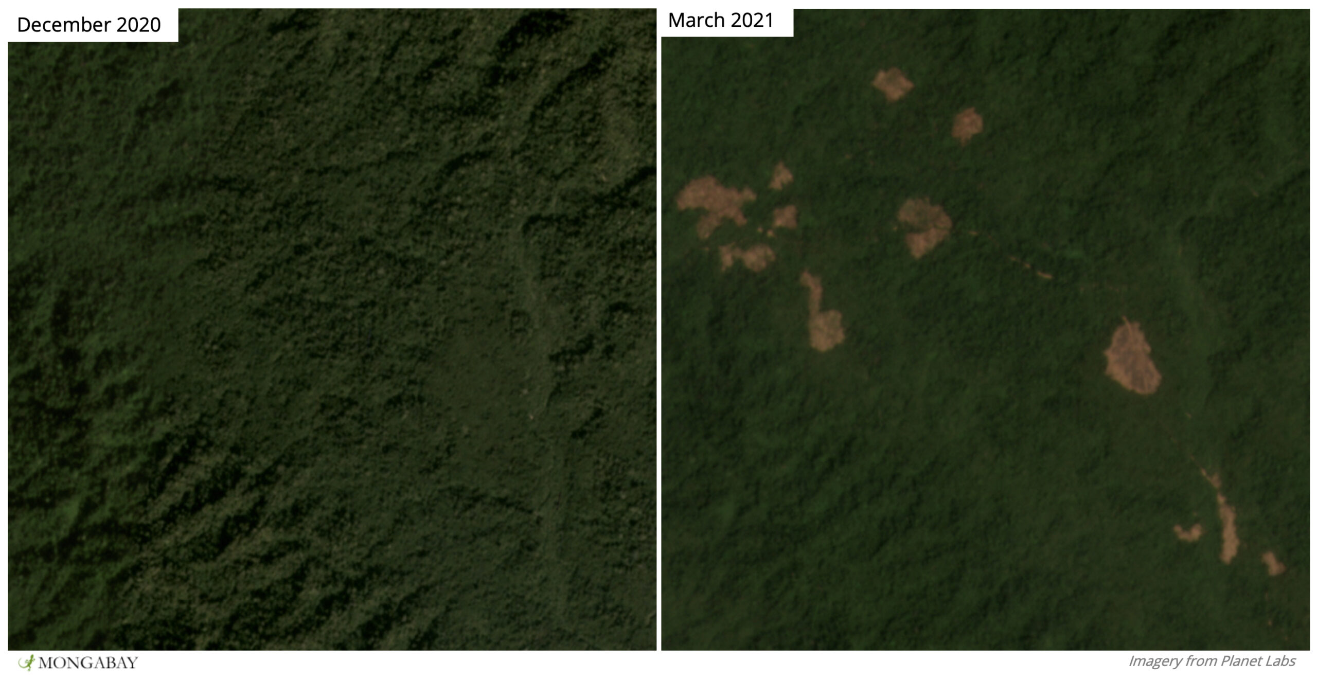
Satellite images show forest clearings expanding inside the southern boundary of Tanintharyi Nature Reserve.
Most of the recent deforestation is taking place just inside the southern boundary of the reserve, where forest loss patterns are consistent with the expansion of clearings that were burned during the first quarter of 2021. Satellite imagery also shows new incursions into primary forest along a road that connects Tanintharyi Nature Reserve to the township of Kameik. Furthermore, deeper within the reserve, satellite imagery shows earthworks proliferating along a pipeline access road and river, where clearings encroach on previously intact areas of primary forest.
Tanintharyi Nature Reserve
Tanintharyi Nature Reserve spans 1,700 km2 (660 mi2) in Dawei district. It was established by the Myanmar government, but funded by oil and gas companies Total, PTT and Petronas as part of a corporate social responsibility program to offset impacts of the controversial Yadana gas pipeline that bisects Tanintharyi from the Andaman Sea coast to the Thai border.
A large portion of the reserve overlaps with land under the management of the Karen National Union (KNU), the main political body for the Karen ethnic group, and encompasses multiple Indigenous Karen and Mon villages. Although the reserve was founded in 2005, it could not be officially implemented until the signing of a cease-fire agreement between the KNU and the central government in 2012.
The nature reserve has been criticized by local groups for failing to respect the rights of Indigenous peoples to their land, resources and livelihoods. According to a report by community-based Karen organizations in Tanintharyi region, the reserve’s protections also hinder the rights of people displaced by war to return to their ancestral lands.
Experts suggest that the nature reserve was promoted by the prevailing government more to secure territorial control of the wider pipeline area from ethnic groups than to conserve biodiversity. “Basically, large-scale conservation rezoning is a crucial territorial strategy to create state administered and patrolled territory in opposition to ethnic armed organization-controlled jurisdictions,” Kevin Woods, a senior policy analyst for U.S.-based nonprofit Forest Trends, told Mongabay.

Recently cleared forest in Tanintharyi, where major drivers of deforestation include expansion of commercial oil palm, rubber and betel nut plantations alongside smallholder cultivation. Image courtesy of FFI-Myanmar
Plantation boom
The establishment of Tanintharyi Nature Reserve was part of a region-wide shift away from subsistence agriculture toward a landscape dominated by protected areas and commercial oil palm and rubber plantations.
Myanmar’s transition to a quasi-civilian government in 2011 and the cease-fire agreement of 2012 created an amenable business environment, further aided by eased international economic sanctions and a slew of business-friendly land reforms. In Tanintharyi, former war zones in borderland forests with weak land tenure were suddenly opened up for business, and a glut of forest clearing ensued, mainly to establish commercial plantations.
A study published in Applied Geography in early 2021 reported that deforestation across Tanintharyi between 2002 and 2016 was driven by the expansion of commercial oil palm, rubber and betel nut plantations alongside smallholder cultivation. The study suggests that the expansion of smallholder agriculture could be due to new commercial oil palm plantations in Tanintharyi encroaching on villagers’ agricultural land. As a result of losing access to their land, many farmers are displaced and left with little choice but to reestablish their crops in the forest.
Such knock-on deforestation is often unnecessary because plantation concessions are rarely fully planted in Tanintharyi. Concessions may not even be intended to grow crops at all, according to researchers and activists who say that companies are clearing forest under the guise of agriculture in order to legally extract commercially valuable timber for trade. A 2015 Forest Trends report found less than one-fifth of the total area demarcated as oil palm concessions in Tanintharyi had actually been planted.
Critical wildlife habitat
Image on the right: Forest habitat for the critically endangered Gurney’s pitta (Hydrornis gurneyi) is in decline. Three main stronghold areas are being eroded by multiple factors. Image by Michael Gillam via Creative Commons (CC BY 2.0)

Sources say infrastructure development for the Dawei Special Economic Zone (SEZ), a central government plan to link up a new deepwater port on the Andaman Sea coast with the Thai border to boost trade and investment, is also exacerbating land scarcity and consequential pressures on the region’s remaining intact forests.
As part of the SEZ, a 138-km (86-mi) highway is under construction between Dawei and southwest Thailand. Conservationists say they’re concerned that the road severs the forested wildlife corridor that links well-protected reserves in Thailand to intact forests in Tanintharyi. Construction firms are also upgrading old logging roads throughout the region to facilitate better trade with neighboring Thailand.
The spate of road construction is driving habitat destruction, according to Saw Soe Aung, who works for Fauna & Flora International in cooperation with local communities to survey forests in southern Tanintharyi for tigers. He said he has witnessed an increase in deforestation along newly constructed roads during 2021, affecting the forest’s capacity to support tigers. “We only recorded one individual of tiger in our survey area this year,” he said. “Before road construction, we recorded four or five individuals.”
Critical habitat for other rare species is also being lost. The entire global population of the Gurney’s pitta, a diminutive but colorful bird that depends on mature forest understory, is found only in the lowland forests of Kawthaung, Tanintharyi’s southernmost district, where more than one-tenth of primary forest has been razed, ostensibly for oil palm.
A recent study led by researchers at King Mongkut’s University of Technology Thonburi, Thailand, found that 8% of suitable habitat for the Gurney’s pitta was lost between 2017 and 2020. Of the remaining habitat, more than 10% is fragmented into patches that are too small to guarantee long-term survival. The study, published in Oryx, estimates that all remaining habitat for the bird will disappear by 2080 unless conservation action is taken.
“Because there is no legal protection, only government forest reserves, there are a lot of land encroachment and land grabbing issues in the southern part of Tanintharyi,” study co-author Nay Myo Shwe told Mongabay.
Forests are particularly vulnerable along newly upgraded roads, which create a “fishbone effect” in newly accessible frontiers and could also “exacerbate existing threats” by facilitating cross-border trade in illicit forest products, including the Gurney’s pittas themselves for the pet market, according to the study.
Image below: Sunda pangolins (Manis javanica) are critically endangered. Forest loss in Tanintharyi fragments their primary habitat. Image by budak via via Flickr/Creative Commons (CC BY-NC-SA 2.0)

Progress in peril
While the period of peace and economic liberalization was accompanied by rapid development in Myanmar, the resurgence of conflict following the ousting of the civilian government in February 2021 has cast uncertainty across the country. Experts are warning of new bouts of deforestation facilitated by weakened governance systems, reduced surveillance, and a lack of accountability.
Meanwhile, villagers, local leaders and civil society organizations say they fear violence and arrests over their environmental activism. As a result, grassroots activism and long-running community-led conservation programs have shut down, said Esther Wah, an Indigenous Karen activist whose fight for customary land rights predates the current regime. The situation threatens to undo much of the progress made in land rights and environmental conservation over the past decade, she said.
“There are a lot of community protected areas in Tanintharyi region, but after the coup, everything stopped and everybody needs to be careful about their security,” Wah said. “If something happened on the ground before, like a development project, we could notice right away which company it was and how many acres were affected — we knew it. But now, we don’t know anything.”
Indigenous activists were working with civil society organizations to have their own approach to conservation recognized in national law. Community conserved areas and Indigenous community conserved areas that focus on both biodiversity and human rights present an alternative to top-down approaches, such as the Tanintharyi Nature Reserve. However, the coup and military crackdowns have brought policy-level negotiations to an abrupt halt.
The turmoil since the coup has so far internally displaced 40,000 people in southeastern Myanmar, according to a U.N. Refugee Agency report. In March and April 2021, 5,000 refugees fled to northern Thailand to escape violent clashes in border regions, most of whom have since been able to return. Over the short-term, at least, there is a risk that displaced people will be forced to eke out a living by farming in Myanmar’s forests. Although fighting has not yet escalated in Tanintharyi and large-scale displacements have not been reported, there is no guarantee that tensions will not rise, Wah said.
“Anything can happen, anything at any time,” she said. “We don’t want any fighting, because if that happens then everything becomes worse. We lose our land, we lose our territory, we lose our livelihoods and our lives will be very difficult.”
*
Note to readers: Please click the share buttons above or below. Follow us on Instagram, @crg_globalresearch. Forward this article to your email lists. Crosspost on your blog site, internet forums. etc.
Sources
Schneider, F., Feurer, M., Lundsgaard-Hansen, L. M., Win Myint, Cing Don Nuam, Nydegger, K., … Messerli, P. (2020). Sustainable development under competing claims on land: Three pathways between land-use changes, ecosystem services and human well-being. The European Journal of Development Research, 32(2), 316-337. doi:10.1057/s41287-020-00268-x
Woods, K. M. (2019). Green territoriality: Conservation as state territorialization in a resource frontier. Human Ecology, 47(2), 217-232. doi:10.1007/s10745-019-0063-x
Schmid, M., Heinimann, A., & Zaehringer, J. G. (2021). Patterns of land system change in a Southeast Asian biodiversity hotspot. Applied Geography, 126, 102380. doi:10.1016/j.apgeog.2020.102380
Savini, T., Shwe, N. M., & Sukumal, N. (2021). Ongoing decline of suitable habitat for the critically endangered gurney’s pitta Hydrornis gurneyi. Oryx, 1-7. doi:10.1017/s0030605320001258
Featured image: A juvenile Malayan tapir , one of many threatened mammal species reportedly present in Tanintharyi’s forests. Image by seth m via Flickr/Creative Commons (CC BY-NC-SA 2.0)